
Make a donation
Gear up for your next adventure:
As an Amazon Associate, this site earns from qualifying purchases at no extra cost to you.
Poperinge topographic map
Click on the map to display elevation.
Make a donation
Gear up for your next adventure:
As an Amazon Associate, this site earns from qualifying purchases at no extra cost to you.
Poperinge
Poperinge ligt in Zandlemig Vlaanderen op een hoogte van ongeveer 25 meter. Het is gelegen in het dal van de Vleterbeek, welke in noordoostelijke richting overgaat in de Poperingevaart. Langs de Poperingevaart bevindt zich het Burggraaf Frimoutpark.
Make a donation
Gear up for your next adventure:
As an Amazon Associate, this site earns from qualifying purchases at no extra cost to you.
About this map
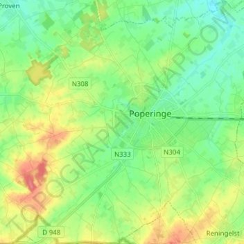
Name: Poperinge topographic map, elevation, terrain.
Location: Poperinge, Ieper, West-Vlaanderen, Vlaanderen, 8970, België (50.81343 2.65805 50.89190 2.78263)
Average elevation: 92 ft
Minimum elevation: 20 ft
Maximum elevation: 213 ft
Make a donation
Gear up for your next adventure:
As an Amazon Associate, this site earns from qualifying purchases at no extra cost to you.
Other topographic maps
Click on a map to view its topography, its elevation and its terrain.
Roesbrugge
België > West-Vlaanderen > Ieper > Poperinge
Roesbrugge ligt aan de IJzer op een hoogte van ongeveer 7 meter. Naar het zuidoosten toe strekt Zandlemig Vlaanderen zich uit, met lichte glooiing. De IJzervallei tussen Roesbrugge-Haringe en Elzendamme en de vallei van de Poperingevaart is een cultuurhistorische ankerplaats.
Average elevation: 23 ft