Geolocate

Sucre topographic map

Click on the map to display elevation.

About this map

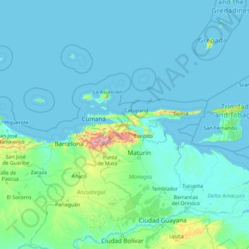
Name: Sucre topographic map, elevation, terrain.

Location: Sucre, Región Nororiental, Venezuela (7.81667 -66.10000 13.01667 -60.90000)

Average elevation: 223 ft

Minimum elevation: -13 ft

Maximum elevation: 8,232 ft

Other topographic maps

Click on a map to view its topography, its elevation and its terrain.

Playa Puy Puy

Venezuela > Sucre > Puipuy

Average elevation: 105 ft

Gear up for your next adventure:

🔥Fast-Boil Camping Stoves - Efficient cooking systems for quick trail meals
🧴Hand Sanitizer - Keep hands clean while hiking
🥘Titanium Cookware - Durable, featherlight pots and pans for backpacking
🦶Hiking Gaiters - Keep debris and water out of your boots
📚Navigation Handbooks - Master the art of reading topographic maps and using a compass

As an Amazon Associate, this site earns from qualifying purchases at no extra cost to you.