
Whitehall topographic map
Click on the map to display elevation.
About this map
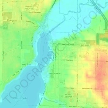
Name: Whitehall topographic map, elevation, terrain.
Location: Whitehall, Muskegon County, Michigan, United States (43.38483 -86.36950 43.42683 -86.31649)
Average elevation: 627 ft
Minimum elevation: 564 ft
Maximum elevation: 728 ft
Muskegon County trails, hiking, mountain biking, running and outdoor activities
Other topographic maps
Click on a map to view its topography, its elevation and its terrain.
Sunset Point
United States > Michigan > Muskegon County > Blue Lake Township
Average elevation: 653 ft