
Thank you for supporting this site ❤️
Make a donation
Make a donation
Gear up for your next adventure:
As an Amazon Associate, this site earns from qualifying purchases at no extra cost to you.
Indaial topographic map
Click on the map to display elevation.
Thank you for supporting this site ❤️
Make a donation
Make a donation
Gear up for your next adventure:
As an Amazon Associate, this site earns from qualifying purchases at no extra cost to you.
Indaial
Indaial localiza-se no Vale do Itajaí, próxima a Blumenau, a uma latitude 26º53'52" sul e a uma longitude 49º13'54" oeste, estando a uma altitude de 64 metros. Possui uma área de 429,97 km².
Thank you for supporting this site ❤️
Make a donation
Make a donation
Gear up for your next adventure:
As an Amazon Associate, this site earns from qualifying purchases at no extra cost to you.
About this map
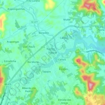
Name: Indaial topographic map, elevation, terrain.
Average elevation: 295 ft
Minimum elevation: 105 ft
Maximum elevation: 1,040 ft
Thank you for supporting this site ❤️
Make a donation
Make a donation
Gear up for your next adventure:
As an Amazon Associate, this site earns from qualifying purchases at no extra cost to you.