Geolocate

Hartley topographic map

Click on the map to display elevation.

About this map

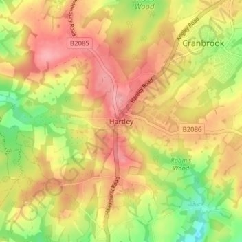
Name: Hartley topographic map, elevation, terrain.

Location: Hartley, Tunbridge Wells, Kent, South East England, England, TN17 3PX, United Kingdom (51.06358 0.49053 51.10358 0.53053)

Average elevation: 308 ft

Minimum elevation: 115 ft

Maximum elevation: 449 ft

Other topographic maps

Click on a map to view its topography, its elevation and its terrain.

Gear up for your next adventure:

🏕️Family Camping Gear - Essentials for group camping trips
🎒Waterproof Dry Bags - Keep your electronics and maps dry inside your pack
🌄Hiking Binoculars - Compact binoculars for scenic views and trail spotting
🌲Outdoor Survival Books - Best books on survival skills
🦶Carbon Trekking Poles - Reduce knee impact on steep descents with ultra-light poles

As an Amazon Associate, this site earns from qualifying purchases at no extra cost to you.