
Make a donation
Gear up for your next adventure:
As an Amazon Associate, this site earns from qualifying purchases at no extra cost to you.
Lohmen topographic map
Click on the map to display elevation.
Make a donation
Gear up for your next adventure:
As an Amazon Associate, this site earns from qualifying purchases at no extra cost to you.
Lohmen
Die Kirche mag Mitte des 13. Jahrhunderts schon im Bau gewesen sein. Seit 1234 war sie Patronatskirche des Dobbertiner Klosters. Als rechteckiger Feldsteinbau, bestehend aus Chor, Schiff und Turm, wurde sie in mehreren Bauphasen errichtet. Der Chor mit seiner geraden Ostwand wurde als erster Bauteil ausgeführt. Er wird auf 1285 datiert. Das rechteckige etwas höhere aus behauenen Feldsteinen und mit einem Satteldach versehene Kirchenschiff soll um 1300 entstanden sein. Der quadratische eingezogene Westturm wurde erst zwischen 1450 und 1560 angebaut. Das Lohmener Gotteshaus ist eine für Mecklenburg typische Feldsteinkirche mit klarer Staffelung der einzelnen Bauglieder.
Make a donation
Gear up for your next adventure:
As an Amazon Associate, this site earns from qualifying purchases at no extra cost to you.
About this map
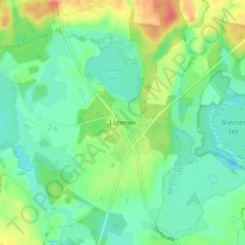
Name: Lohmen topographic map, elevation, terrain.
Average elevation: 161 ft
Minimum elevation: 108 ft
Maximum elevation: 266 ft
Make a donation
Gear up for your next adventure:
As an Amazon Associate, this site earns from qualifying purchases at no extra cost to you.