
Make a donation
Gear up for your next adventure:
As an Amazon Associate, this site earns from qualifying purchases at no extra cost to you.
Goßmannsdorf topographic map
Click on the map to display elevation.
Make a donation
Gear up for your next adventure:
As an Amazon Associate, this site earns from qualifying purchases at no extra cost to you.
Goßmannsdorf
Vom 14. bis ins 19. Jahrhundert hatte der Ort eine geschlossene Dorfbefestigung, die aus einer Ringmauer mit drei großen und sieben kleinen Türmen bestand. Sie ist nur noch teilweise in ihrer alten Höhe erhalten.
Make a donation
Gear up for your next adventure:
As an Amazon Associate, this site earns from qualifying purchases at no extra cost to you.
About this map
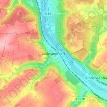
Name: Goßmannsdorf topographic map, elevation, terrain.
Average elevation: 807 ft
Minimum elevation: 564 ft
Maximum elevation: 1,033 ft
Make a donation
Gear up for your next adventure:
As an Amazon Associate, this site earns from qualifying purchases at no extra cost to you.
Other topographic maps
Click on a map to view its topography, its elevation and its terrain.