Geolocate

Benton Harbor topographic map

Click on the map to display elevation.

About this map

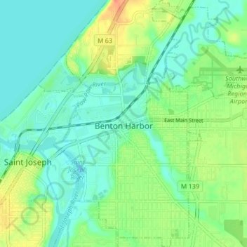
Name: Benton Harbor topographic map, elevation, terrain.

Location: Benton Harbor, Berrien County, Michigan, United States (42.09256 -86.47721 42.14175 -86.41093)

Average elevation: 610 ft

Minimum elevation: 564 ft

Maximum elevation: 709 ft

Berrien County trails, hiking, mountain biking, running and outdoor activities

Other topographic maps

Click on a map to view its topography, its elevation and its terrain.

Snow

United States > Michigan > Berrien County

Average elevation: 653 ft

Harbert

United States > Michigan > Berrien County

Average elevation: 630 ft

Rosemary Beach

United States > Michigan > Berrien County

Average elevation: 600 ft

Millburg

United States > Michigan > Berrien County > Millburg

Average elevation: 682 ft

Hartman

United States > Michigan > Berrien County

Average elevation: 699 ft

Gear up for your next adventure:

🛠️Backpacking Tool Kit - Essential toolkit for outdoor repairs
🧭Hiking Compass - Precision compass for reliable navigation in the wilderness
🌲Outdoor Survival Books - Best books on survival skills
🦟Ultrasonic Repellers - Create a bug-free zone at your camp or rest stop
🔦Powerful Headlamps - Ultra-bright hands-free lighting for night navigation

As an Amazon Associate, this site earns from qualifying purchases at no extra cost to you.