Geolocate

Polegate topographic map

Click on the map to display elevation.

About this map

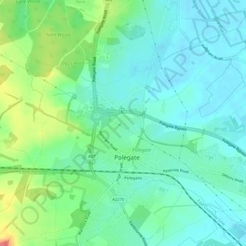
Name: Polegate topographic map, elevation, terrain.

Location: Polegate, Wealden, East Sussex, England, United Kingdom (50.81321 0.22430 50.84212 0.27603)

Average elevation: 59 ft

Minimum elevation: 0 ft

Maximum elevation: 213 ft

Gear up for your next adventure:

📶Satellite Messenger - Communication device off‑grid
🩳Quick‑Dry Hiking Shorts - Comfortable and quick‑dry shorts for summer hiking
🪶Compact Camp Shovel - Folding shovel for campsite tasks
🧭Map Reading Tools - Tools and kits for map navigation
🦶Hiking Gaiters - Keep debris and water out of your boots

As an Amazon Associate, this site earns from qualifying purchases at no extra cost to you.