Geolocate

Sparta topographic map

Click on the map to display elevation.

About this map

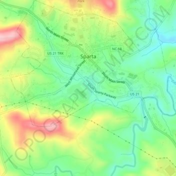
Name: Sparta topographic map, elevation, terrain.

Location: Sparta, Alleghany County, North Carolina, United States (36.48160 -81.14003 36.51677 -81.09786)

Average elevation: 2,930 ft

Minimum elevation: 2,680 ft

Maximum elevation: 3,323 ft

Alleghany County trails, hiking, mountain biking, running and outdoor activities

Other topographic maps

Click on a map to view its topography, its elevation and its terrain.

Roaring Gap

United States > North Carolina > Alleghany County

Average elevation: 2,756 ft

Piney Creek

United States > North Carolina > Alleghany County

Average elevation: 2,753 ft

Kings Creek

United States > North Carolina > Alleghany County

Average elevation: 2,723 ft

Ennice

United States > North Carolina > Alleghany County

Average elevation: 2,605 ft

Ennice

United States > North Carolina > Alleghany County

Average elevation: 2,605 ft

Ennice

United States > North Carolina > Alleghany County

Average elevation: 2,605 ft

Piney Creek

United States > North Carolina > Alleghany County

Average elevation: 2,753 ft

Roaring Gap

United States > North Carolina > Alleghany County

Average elevation: 2,756 ft

Gear up for your next adventure:

🔋Rechargeable Batteries - Power up your outdoor devices
🥾Women's Hiking Boots - Top-rated trail boots with ankle support and superior grip
🗺️NatGeo Topo Maps - High-quality waterproof printed topographic maps of US Parks
🪓Survival Multi‑Tool - Versatile tool for camp and trail tasks
🛶Inflatable Kayak - Portable kayak for rivers, lakes, and expeditions

As an Amazon Associate, this site earns from qualifying purchases at no extra cost to you.