
Make a donation
Gear up for your next adventure:
As an Amazon Associate, this site earns from qualifying purchases at no extra cost to you.
茶卡盐湖 topographic map
Click on the map to display elevation.
Make a donation
Gear up for your next adventure:
As an Amazon Associate, this site earns from qualifying purchases at no extra cost to you.
茶卡盐湖
茶卡盐湖,也称茶卡(藏語:ཚྭ་ཁ།,藏语拼音:Caka 意为“盐湖”,通名作专名)或达布逊淖尔(蒙古语:ᠳᠠᠪᠤᠰᠤᠨ ᠨᠠᠭᠤᠷ,西里尔字母:давс нуур,Dabsûn Nûûr,意为“盐湖”,通名作专名),位于中国青海省海西蒙古族藏族自治州乌兰县茶卡镇境内,湖面海拔为3059米。
Make a donation
Gear up for your next adventure:
As an Amazon Associate, this site earns from qualifying purchases at no extra cost to you.
About this map
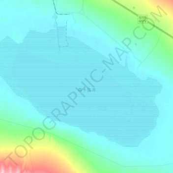
Name: 茶卡盐湖 topographic map, elevation, terrain.
Location: 茶卡盐湖, 乌兰县, 海西蒙古族藏族自治州, 青海省, 817100, 中国 (36.63850 99.00324 36.75003 99.20085)
Average elevation: 10,118 ft
Minimum elevation: 10,036 ft
Maximum elevation: 10,702 ft
Make a donation
Gear up for your next adventure:
As an Amazon Associate, this site earns from qualifying purchases at no extra cost to you.
Other topographic maps
Click on a map to view its topography, its elevation and its terrain.
Make a donation
Gear up for your next adventure:
As an Amazon Associate, this site earns from qualifying purchases at no extra cost to you.