Geolocate

Lebanon topographic map

Click on the map to display elevation.

About this map

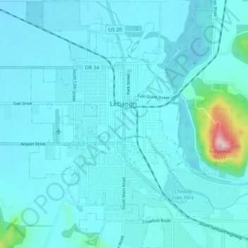
Name: Lebanon topographic map, elevation, terrain.

Location: Lebanon, Linn County, Oregon, 97355, United States (44.50154 -122.93894 44.56118 -122.87069)

Average elevation: 384 ft

Minimum elevation: 308 ft

Maximum elevation: 1,181 ft

Linn County trails, hiking, mountain biking, running and outdoor activities

Other topographic maps

Click on a map to view its topography, its elevation and its terrain.

Tamolitch Falls

United States > Oregon > Linn County

Average elevation: 2,864 ft

Clear Lake

United States > Oregon > Linn County

Average elevation: 3,291 ft

Cascadia

United States > Oregon > Linn County

Average elevation: 1,362 ft

Gear up for your next adventure:

🏕️Family Camping Gear - Essentials for group camping trips
📡Handheld GPS Device - Reliable handheld GPS for outdoor navigation
🏥Hiking First Aid Kits - Comprehensive medical kits for remote trail injuries
🔦Powerful Headlamps - Ultra-bright hands-free lighting for night navigation
🥄Camping Utensil Set - Lightweight utensils for outdoor meals

As an Amazon Associate, this site earns from qualifying purchases at no extra cost to you.