
Make a donation
Gear up for your next adventure:
As an Amazon Associate, this site earns from qualifying purchases at no extra cost to you.
La Florida topographic map
Click on the map to display elevation.
Make a donation
Gear up for your next adventure:
As an Amazon Associate, this site earns from qualifying purchases at no extra cost to you.
About this map
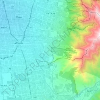
Name: La Florida topographic map, elevation, terrain.
Average elevation: 3,159 ft
Minimum elevation: 1,785 ft
Maximum elevation: 9,285 ft
Make a donation
Gear up for your next adventure:
As an Amazon Associate, this site earns from qualifying purchases at no extra cost to you.
Other topographic maps
Click on a map to view its topography, its elevation and its terrain.
Parque Metropolitano de Santiago
Chile > Región Metropolitana de Santiago > Provincia de Santiago > Providencia
Average elevation: 2,005 ft
Parque Araucano
Chile > Región Metropolitana de Santiago > Provincia de Santiago
Average elevation: 2,241 ft
Cerro Santa Lucía
Chile > Región Metropolitana de Santiago > Provincia de Santiago > Santiago
El cerro Santa lucia, antiguamente llamado el cerro Huelén , es un parque urbano ubicado en el corazón de la ciudad de Santiago de Chile. Limita al sur con la Avenida Libertador General Bernardo O'Higgins, donde se encuentra la estación Santa Lucía del Metro de Santiago, al oeste con la calle Santa…
Average elevation: 1,880 ft
Parque Natural Quebrada de Macul
Chile > Región Metropolitana de Santiago > Provincia de Santiago > Peñalolén
Average elevation: 6,070 ft
Make a donation
Gear up for your next adventure:
As an Amazon Associate, this site earns from qualifying purchases at no extra cost to you.
Parque La Platina
Chile > Región Metropolitana de Santiago > Provincia de Santiago
Average elevation: 2,077 ft
Camino La Botella
Chile > Región Metropolitana de Santiago > Provincia de Santiago > Pudahuel
Average elevation: 1,588 ft
Parque Forestal
Chile > Región Metropolitana de Santiago > Provincia de Santiago > Santiago
Average elevation: 1,916 ft
Parque Lo Errazuriz
Chile > Región Metropolitana de Santiago > Provincia de Santiago > Cerrillos
Average elevation: 1,624 ft
Make a donation
Gear up for your next adventure:
As an Amazon Associate, this site earns from qualifying purchases at no extra cost to you.
Peralito
Chile > Región Metropolitana de Santiago > Provincia de Santiago > Pudahuel > Peralito
Average elevation: 1,552 ft
Farellones
Chile > Región Metropolitana de Santiago > Provincia de Santiago > Lo Barnechea
Average elevation: 7,359 ft