Geolocate

Gerik topographic map

Click on the map to display elevation.

About this map

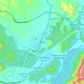
Name: Gerik topographic map, elevation, terrain.

Location: Gerik, Perak, 333000, Malaysia (5.39066 101.08964 5.47066 101.16964)

Average elevation: 535 ft

Minimum elevation: 351 ft

Maximum elevation: 1,437 ft

Gear up for your next adventure:

🪄Magnetic Compass - Accurate compass for navigation
📱Solar Portable Charger - Solar power bank for charging devices off‑grid
🦶Hiking Gaiters - Keep debris and water out of your boots
🪶Compact Camp Shovel - Folding shovel for campsite tasks
📌Outdoor GPS Map App - Apps and devices for digital topographic navigation

As an Amazon Associate, this site earns from qualifying purchases at no extra cost to you.