
Saintfield topographic map
Interactive map
Click on the map to display elevation.
About this map
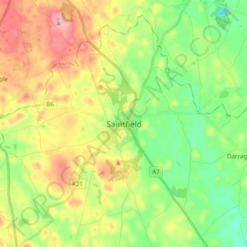
Name: Saintfield topographic map, elevation, terrain.
Average elevation: 285 ft
Minimum elevation: 62 ft
Maximum elevation: 614 ft
Other topographic maps
Click on a map to view its topography, its elevation and its terrain.
Newry
United Kingdom > Northern Ireland > County Down
Newry, County Down, Northern Ireland, United Kingdom
Average elevation: 240 ft
Dundonald
United Kingdom > Northern Ireland > County Down
Dundonald, County Down, Ulster, Northern Ireland, BT16 1RH, United Kingdom
Average elevation: 262 ft
Killough
United Kingdom > Northern Ireland > County Down
Killough, County Down, Ulster, Northern Ireland, BT30 7QQ, United Kingdom
Average elevation: 23 ft
Ballynahinch
United Kingdom > Northern Ireland > County Down > Ballynahinch
Ballynahinch, County Down, Ulster, Northern Ireland, BT24 8DN, United Kingdom
Average elevation: 325 ft
Lawrencetown
United Kingdom > Northern Ireland > County Down
Lawrencetown, County Down, Northern Ireland, BT63 6DU, United Kingdom
Average elevation: 236 ft
County Down
United Kingdom > Northern Ireland > County Down
County Down, Northern Ireland, United Kingdom
Average elevation: 213 ft