
Tettenweis topographic map
Interactive map
Click on the map to display elevation.
About this map
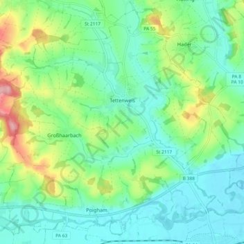
Name: Tettenweis topographic map, elevation, terrain.
Location: Tettenweis, Landkreis Passau, Bavaria, 94167, Germany (48.40841 13.22580 48.46450 13.31729)
Average elevation: 1,175 ft
Minimum elevation: 1,043 ft
Maximum elevation: 1,512 ft
Other topographic maps
Click on a map to view its topography, its elevation and its terrain.
Aldersbach
Germany > Bavaria > Landkreis Passau
Aldersbach, Landkreis Passau, Bavaria, 94501, Germany
Average elevation: 1,181 ft