Geolocate

Tunal topographic map

Click on the map to display elevation.

About this map

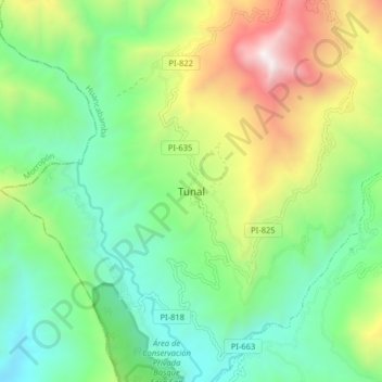
Name: Tunal topographic map, elevation, terrain.

Location: Tunal, Lalaquiz, Huancabamba, Piura, Perú (-5.25553 -79.71997 -5.17553 -79.63997)

Average elevation: 3,022 ft

Minimum elevation: 965 ft

Maximum elevation: 7,192 ft

Gear up for your next adventure:

🪵Folding Camp Saw - Compact saw for wood and campsite work
🌲Outdoor Survival Books - Best books on survival skills
🎒Gear Packing Cubes - Organize your backpack efficiently
🔥Plasma Lighters - Windproof lighters that work in any weather condition
🧤Tactile Hiking Gloves - Keep hands warm while operating GPS and smartphone screens

As an Amazon Associate, this site earns from qualifying purchases at no extra cost to you.