
Make a donation
Gear up for your next adventure:
As an Amazon Associate, this site earns from qualifying purchases at no extra cost to you.
Biebergemünd topographic map
Click on the map to display elevation.
Make a donation
Gear up for your next adventure:
As an Amazon Associate, this site earns from qualifying purchases at no extra cost to you.
Biebergemünd
Das Gemeindegebiet von Biebergemünd erstreckt sich durch das gesamte Biebertal vom Oberlauf bis zur Mündung in die Kinzig. Die Bieber entspringt im Ortsteil Bieber, schlängelt sich in nördlicher Richtung durch das Biebertal und mündet in Biebergemünd-Wirtheim in die Kinzig. Jenseits der Kinzig im Anschluss an den Bahnhof Wirtheim liegt noch der Teilort Neuwirtheim. Nördlich oberhalb von Neuwirtheim, liegt der bereits zur Gemarkung Wächtersbach und zum Vogelsberg zählende Aspenhainer Kopf (260 m über NHN). Der topographisch höchste Punkt des Gemeindegebietes befindet sich mit etwa 520 m ü. NHN unterhalb des Gipfels des Langen Berges im Spessart.
Make a donation
Gear up for your next adventure:
As an Amazon Associate, this site earns from qualifying purchases at no extra cost to you.
About this map
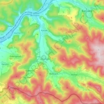
Name: Biebergemünd topographic map, elevation, terrain.
Location: Biebergemünd, Main-Kinzig-Kreis, Hessen, 63599, Deutschland (50.13052 9.24254 50.23867 9.40521)
Average elevation: 978 ft
Minimum elevation: 420 ft
Maximum elevation: 1,772 ft
Make a donation
Gear up for your next adventure:
As an Amazon Associate, this site earns from qualifying purchases at no extra cost to you.
Other topographic maps
Click on a map to view its topography, its elevation and its terrain.
Lettgenbrunn (Gemeinde Jossgrund)
Deutschland > Hessen > Main-Kinzig-Kreis > Lettgenbrunn (Gemeinde Jossgrund)
Average elevation: 1,516 ft
Make a donation
Gear up for your next adventure:
As an Amazon Associate, this site earns from qualifying purchases at no extra cost to you.
Ramholz
Deutschland > Hessen > Main-Kinzig-Kreis > Vollmerz
Ramholz liegt auf einer Höhe von 320 m über NN, etwa 6,5 km südöstlich des Stadtkerns von Schlüchtern.
Average elevation: 1,224 ft
Make a donation
Gear up for your next adventure:
As an Amazon Associate, this site earns from qualifying purchases at no extra cost to you.
Landrücken
Deutschland > Hessen > Main-Kinzig-Kreis > Hutten
Der Hessische Landrücken (meist nur Landrücken genannt) ist ein in etwa Ost-West-Richtung verlaufender, etwa 13 km langer und nach Osten bis knapp 595,6 m ü. NHN hoher Basaltrücken im deutschen Bundesland Hessen. Der in Osthessen gelegene Höhenzug ist als Teil der Rhein-Weser-Wasserscheide Bindeglied…
Average elevation: 1,247 ft
Make a donation
Gear up for your next adventure:
As an Amazon Associate, this site earns from qualifying purchases at no extra cost to you.
Altwiedermus
Deutschland > Hessen > Main-Kinzig-Kreis
Die Antsanvia, eine Altstraße, verlief über die Anhöhen zwischen Langen-Bergheim und Altwiedermus und weiter über Diebach am Haag und Herrnhaag. Der Ort wird im Jahre 1173 erstmals urkundlich erwähnt. Der Ortsname hatte verschiedene historische Formen: Wechtramis, Witteroms und Wyderamis. 1236 wurde eine…
Average elevation: 623 ft
Make a donation
Gear up for your next adventure:
As an Amazon Associate, this site earns from qualifying purchases at no extra cost to you.
Niederdorfelden
Deutschland > Hessen > Main-Kinzig-Kreis > Niederdorfelden
Niederdorfelden liegt auf einer Höhe von 111 m über NN, 4 km nordöstlich der Stadtmitte von Bad Vilbel und 12 km nordöstlich der Stadtmitte von Frankfurt am Main.
Average elevation: 430 ft
Weinberg bei Hohenzell
Deutschland > Hessen > Main-Kinzig-Kreis > Schlüchtern
Average elevation: 1,178 ft
Make a donation
Gear up for your next adventure:
As an Amazon Associate, this site earns from qualifying purchases at no extra cost to you.