
Make a donation
Gear up for your next adventure:
As an Amazon Associate, this site earns from qualifying purchases at no extra cost to you.
Verona Island topographic map
Click on the map to display elevation.
Make a donation
Gear up for your next adventure:
As an Amazon Associate, this site earns from qualifying purchases at no extra cost to you.
Verona Island
The highest point is McCloud Mountain, at an elevation of 344 feet (105 m) above sea level.
Make a donation
Gear up for your next adventure:
As an Amazon Associate, this site earns from qualifying purchases at no extra cost to you.
About this map
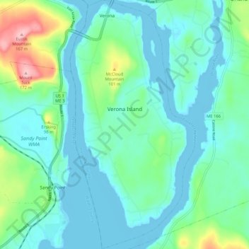
Name: Verona Island topographic map, elevation, terrain.
Location: Verona Island, Hancock County, Maine, 04416, United States (44.49669 -68.80561 44.56992 -68.75388)
Average elevation: 108 ft
Minimum elevation: -23 ft
Maximum elevation: 548 ft
Hancock County trails, hiking, mountain biking, running and outdoor activities
Make a donation
Gear up for your next adventure:
As an Amazon Associate, this site earns from qualifying purchases at no extra cost to you.
Other topographic maps
Click on a map to view its topography, its elevation and its terrain.
Cadillac Mountain
United States > Maine > Hancock County > Bar Harbor
Cadillac Mountain is located on Mount Desert Island, within Acadia National Park, in the U.S. state of Maine. With an elevation of nearly 1,530 feet (470 meters), its summit is the highest point in Hancock County and the highest within 25 miles (40 km) of the Atlantic shoreline of the North American continent…
Average elevation: 764 ft
Make a donation
Gear up for your next adventure:
As an Amazon Associate, this site earns from qualifying purchases at no extra cost to you.
Make a donation
Gear up for your next adventure:
As an Amazon Associate, this site earns from qualifying purchases at no extra cost to you.
Cadillac Mountain
United States > Maine > Hancock County > Bar Harbor
Cadillac Mountain is located on Mount Desert Island, within Acadia National Park, in the U.S. state of Maine. With an elevation of 1,530 feet (470 meters), its summit is the highest point in Hancock County and the highest within 25 miles (40 km) of the Atlantic shoreline of the North American continent between…
Average elevation: 764 ft
Make a donation
Gear up for your next adventure:
As an Amazon Associate, this site earns from qualifying purchases at no extra cost to you.
Make a donation
Gear up for your next adventure:
As an Amazon Associate, this site earns from qualifying purchases at no extra cost to you.