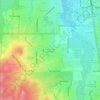
Sedalia topographic map
Click on the map to display elevation.
About this map
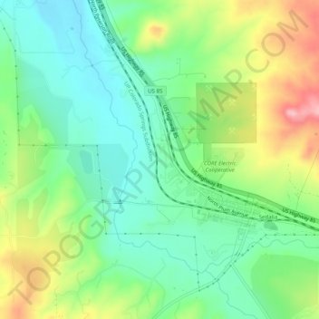
Name: Sedalia topographic map, elevation, terrain.
Location: Sedalia, Douglas County, Colorado, 80135, United States (39.43039 -104.98717 39.45712 -104.93773)
Average elevation: 5,863 ft
Minimum elevation: 5,663 ft
Maximum elevation: 6,230 ft
Douglas County trails, hiking, mountain biking, running and outdoor activities
Other topographic maps
Click on a map to view its topography, its elevation and its terrain.
Parker
United States > Colorado > Douglas County
Parker is located in northeastern Douglas County. Its northernmost border follows the Arapahoe County line, and the city of Aurora touches the town's northeast border. The center of Parker is 23 miles (37 km) southeast of downtown Denver. Castle Rock, the Douglas County seat, is 15 miles (24 km) to the…
Average elevation: 6,053 ft
Castle Rock
United States > Colorado > Douglas County
Castle Rock is located at 39°22′20″N 104°51′22″W / 39.37222°N 104.85611°W / 39.37222; -104.85611 (39.372212, −104.856090) at an elevation of 6,224 feet (1,897 m). Castle Rock is in central Colorado at the junction of Interstate 25 and State Highway 86, 28 mi (45 km) south of downtown…
Average elevation: 6,404 ft
Parker
United States > Colorado > Douglas County
Parker is located in northeastern Douglas County. Its northernmost border follows the Arapahoe County line, and the city of Aurora touches the town's northeast border. The center of Parker is 23 miles (37 km) southeast of downtown Denver. Castle Rock, the Douglas County seat, is 15 miles (24 km) to the…
Average elevation: 6,053 ft
Castle Rock
United States > Colorado > Douglas County
Castle Rock is located at 39°22′20″N 104°51′22″W / 39.37222°N 104.85611°W / 39.37222; -104.85611 (39.372212, −104.856090) at an elevation of 6,224 feet (1,897 m). Castle Rock is in central Colorado at the junction of Interstate 25 and State Highway 86, 28 mi (45 km) south of downtown…
Average elevation: 6,404 ft

Highlands Ranch
United States > Colorado > Douglas County > Highlands Ranch
Average elevation: 5,778 ft

Castle Pines
United States > Colorado > Douglas County
Castle Pines is located at 39°28′18″N 104°53′41″W / 39.471742°N 104.894827°W / 39.471742; -104.894827 (39.471742, -104.894827) at an elevation of 6,368 feet (1,941 m). Located on Interstate 25 in central Colorado, Castle Pines is 20 mi (32 km) south of downtown Denver and 43 mi (69 km)…
Average elevation: 6,312 ft

Highlands Ranch
United States > Colorado > Douglas County > Highlands Ranch
Average elevation: 5,778 ft
Lone Tree
United States > Colorado > Douglas County
Lone Tree is located on the northern border of Douglas County, directly adjacent to Arapahoe County, approximately 18 miles (29 km) south of downtown Denver. Neighboring communities include Centennial to the north, Highlands Ranch to the west, and Parker to the southeast. The Meridian International Business…
Average elevation: 5,965 ft
Castle Pines
United States > Colorado > Douglas County
Castle Pines is located at 39°28′18″N 104°53′41″W / 39.471742°N 104.894827°W / 39.471742; -104.894827 (39.471742, -104.894827) at an elevation of 6,368 feet (1,941 m). Located on Interstate 25 in central Colorado, Castle Pines is 20 mi (32 km) south of downtown Denver and 43 mi (69 km)…
Average elevation: 6,312 ft

Parker
United States > Colorado > Douglas County
Parker is located in northeastern Douglas County. Its northernmost border follows the Arapahoe County line, and the city of Aurora touches the town's northeast border. The center of Parker is 23 miles (37 km) southeast of downtown Denver. Castle Rock, the Douglas County seat, is 15 miles (24 km) to the…
Average elevation: 6,053 ft