
Lone Tree topographic map
Click on the map to display elevation.
About this map
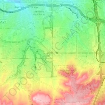
Name: Lone Tree topographic map, elevation, terrain.
Location: Lone Tree, Douglas County, Colorado, 80124, United States (39.50710 -104.90935 39.56648 -104.82991)
Average elevation: 5,965 ft
Minimum elevation: 5,676 ft
Maximum elevation: 6,358 ft
Douglas County trails, hiking, mountain biking, running and outdoor activities
Other topographic maps
Click on a map to view its topography, its elevation and its terrain.
Hidden Mesa Open Space
United States > Colorado > Douglas County > Castle Rock
Average elevation: 6,240 ft