Geolocate

Killashandra topographic map

Click on the map to display elevation.

About this map
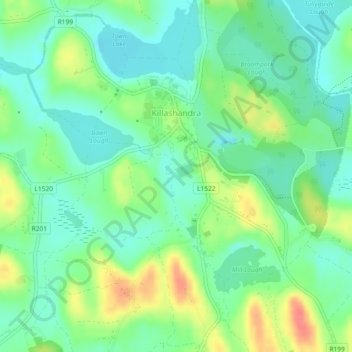
Name: Killashandra topographic map, elevation, terrain.

Location: Killashandra, Killashandra ED, Cavan-Belturbet Municipal District, County Cavan, Ulster, Ireland (54.00177 -7.53668 54.01774 -7.51441)

Average elevation: 203 ft

Minimum elevation: 131 ft

Maximum elevation: 338 ft

Other topographic maps

Click on a map to view its topography, its elevation and its terrain.

Cock Island

Ireland > County Cavan

Average elevation: 295 ft

Mullagh

Ireland > County Cavan > Mullagh

Average elevation: 384 ft

Killinkere

Ireland > County Cavan

Average elevation: 407 ft

Tawlaght

Ireland > County Cavan

Average elevation: 305 ft

Blacklion

Ireland > County Cavan

Average elevation: 302 ft

Legnagrow Lough

Ireland > County Cavan > Glangevlin

Average elevation: 453 ft

Bawnboy

Ireland > County Cavan

Average elevation: 331 ft

Rampart River

Ireland > County Cavan

Average elevation: 341 ft

Gear up for your next adventure:

⛺Backpacking Tent - Lightweight and durable tent for multi‑day hikes
🎒Gear Packing Cubes - Organize your backpack efficiently
🎒Trail Energy Bars - High‑calorie bars for hiking energy
🧼Biodegradable Camping Soap - Eco‑friendly soap for outdoor hygiene
🥾Hiking Shoes - Durable and comfortable shoes for trail hiking

As an Amazon Associate, this site earns from qualifying purchases at no extra cost to you.