
Thank you for supporting this site ❤️
Make a donation
Make a donation
Gear up for your next adventure:
As an Amazon Associate, this site earns from qualifying purchases at no extra cost to you.
Mahadevapura topographic map
Click on the map to display elevation.
Thank you for supporting this site ❤️
Make a donation
Make a donation
Gear up for your next adventure:
As an Amazon Associate, this site earns from qualifying purchases at no extra cost to you.
About this map
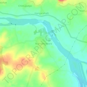
Name: Mahadevapura topographic map, elevation, terrain.
Average elevation: 2,218 ft
Minimum elevation: 2,139 ft
Maximum elevation: 2,356 ft
Thank you for supporting this site ❤️
Make a donation
Make a donation
Gear up for your next adventure:
As an Amazon Associate, this site earns from qualifying purchases at no extra cost to you.
Other topographic maps
Click on a map to view its topography, its elevation and its terrain.
Ranganathittu Bird Sanctuary
India > Karnataka > Srirangapattana taluk > Krishnarajasagara
Average elevation: 2,415 ft
Krishnaraja Sagara Dam
India > Karnataka > Srirangapattana taluk > Krishnarajasagara
Average elevation: 2,428 ft