
Make a donation
Gear up for your next adventure:
As an Amazon Associate, this site earns from qualifying purchases at no extra cost to you.
Djelfa topographic map
Click on the map to display elevation.
Make a donation
Gear up for your next adventure:
As an Amazon Associate, this site earns from qualifying purchases at no extra cost to you.
Djelfa
Djelfa is located at an elevation of 3,734 feet (1,138 m) in the Ouled Naïl Range of north-central Algeria, between the towns of Bousaada and Laghouat. It is situated in a transitional zone between the dry, steppe-like Hautes Plaines (high plateaus) of the north, characterized by chotts (intermittent salt lakes), and the Sahara to the south. The town was founded in 1852 as a French military post on a geometric plan. It serves as an important livestock market centre for the semi-nomadic Ouled Naïl confederation. Djelfa is on the 12,000 mile-long Africa Trail.
Make a donation
Gear up for your next adventure:
As an Amazon Associate, this site earns from qualifying purchases at no extra cost to you.
About this map
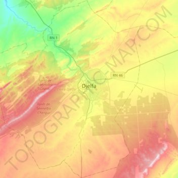
Name: Djelfa topographic map, elevation, terrain.
Location: Djelfa, Djelfa District, Djelfa, Algeria (34.52510 3.06894 34.80481 3.35258)
Average elevation: 3,917 ft
Minimum elevation: 3,077 ft
Maximum elevation: 4,862 ft
Make a donation
Gear up for your next adventure:
As an Amazon Associate, this site earns from qualifying purchases at no extra cost to you.