
Make a donation
Gear up for your next adventure:
As an Amazon Associate, this site earns from qualifying purchases at no extra cost to you.
Altenglan topographic map
Click on the map to display elevation.
Make a donation
Gear up for your next adventure:
As an Amazon Associate, this site earns from qualifying purchases at no extra cost to you.
Altenglan
The municipality lies in the uplands in the Western Palatinate on the river Glan, which is the village's namesake, at an elevation in the valley of some 200 m above sea level, although the elevations within municipal limits reach almost 400 m (Bistersberg 387 m on the Glan's left bank; Kalmet 390 m on the Glan's right bank), and on the slopes of the Potzberg within the formerly self-administering municipality of Mühlbach almost 500 m. Altenglan lies roughly 5 km northeast of the district seat and nearest town, Kusel, and 25 km northwest of Kaiserslautern. In Altenglan, the Kuselbach and the Reichenbach empty into the Glan. The dale here forms a broad bowl, although the pattern is broken somewhat by the two streams that meet the Glan here, one from each side. Part of the Potzberg massif lies within Altenglan as does part of the long Remigiusberg ridge, although these hills' summits all lie outside the municipality's boundaries. The municipality has an area of 1 362 ha, of which 237 ha is wooded.
Make a donation
Gear up for your next adventure:
As an Amazon Associate, this site earns from qualifying purchases at no extra cost to you.
About this map
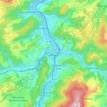
Name: Altenglan topographic map, elevation, terrain.
Average elevation: 1,001 ft
Minimum elevation: 627 ft
Maximum elevation: 1,841 ft
Make a donation
Gear up for your next adventure:
As an Amazon Associate, this site earns from qualifying purchases at no extra cost to you.
Other topographic maps
Click on a map to view its topography, its elevation and its terrain.
Schönenberg
Germany > Rhineland-Palatinate > Landkreis Kusel > Schönenberg-Kübelberg
Average elevation: 873 ft