Geolocate

Cascade Falls topographic map

Click on the map to display elevation.

About this map

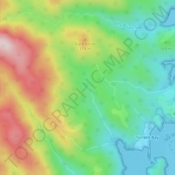
Name: Cascade Falls topographic map, elevation, terrain.

Location: Cascade Falls, Tasman, New Zealand (-40.93815 173.03656 -40.93805 173.03666)

Average elevation: 584 ft

Minimum elevation: 0 ft

Maximum elevation: 1,532 ft

Other topographic maps

Click on a map to view its topography, its elevation and its terrain.

Tonga Island

New Zealand > Tasman

Average elevation: 30 ft

Gear up for your next adventure:

💧Water Filtration Bottles - Safely drink from streams and lakes while exploring
🪶Fire Starter Kit - Reliable fire starter for survival and camping
🧭Compass with Lanyard - Easy‑carry compass for navigation
🥾Hiking Shoes - Durable and comfortable shoes for trail hiking
🎁Geography Themed Gifts - Unique gift ideas for map lovers and geography enthusiasts

As an Amazon Associate, this site earns from qualifying purchases at no extra cost to you.