
Thank you for supporting this site ❤️
Make a donation
Make a donation
Gear up for your next adventure:
As an Amazon Associate, this site earns from qualifying purchases at no extra cost to you.
Kalapet topographic map
Click on the map to display elevation.
Thank you for supporting this site ❤️
Make a donation
Make a donation
Gear up for your next adventure:
As an Amazon Associate, this site earns from qualifying purchases at no extra cost to you.
About this map
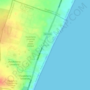
Name: Kalapet topographic map, elevation, terrain.
Location: Kalapet, Ozhukarai Taluk, Puducherry, 605014, India (12.01084 79.84484 12.05084 79.88484)
Average elevation: 46 ft
Minimum elevation: -3 ft
Maximum elevation: 148 ft
Thank you for supporting this site ❤️
Make a donation
Make a donation
Gear up for your next adventure:
As an Amazon Associate, this site earns from qualifying purchases at no extra cost to you.