Geolocate

Cedar Point topographic map

Click on the map to display elevation.

About this map

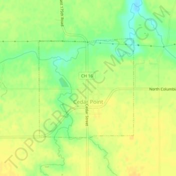
Name: Cedar Point topographic map, elevation, terrain.

Location: Cedar Point, LaSalle County, Illinois, 61316, United States (41.25760 -89.13575 41.27282 -89.11633)

Average elevation: 656 ft

Minimum elevation: 604 ft

Maximum elevation: 679 ft

LaSalle County trails, hiking, mountain biking, running and outdoor activities

Other topographic maps

Click on a map to view its topography, its elevation and its terrain.

Wedron

United States > Illinois > LaSalle County

Average elevation: 587 ft

Dayton

United States > Illinois > LaSalle County

Average elevation: 587 ft

Hitt

United States > Illinois > LaSalle County > Ottawa

Average elevation: 571 ft

Serena

United States > Illinois > LaSalle County

Average elevation: 630 ft

Gear up for your next adventure:

🎒Trekking Poles - Sturdy poles for balance and stability on rough terrain
🛡️Insect Repellent - Protection against bugs during outdoor activities
🖼️Topo Map Wall Art - Decorative topographic prints of famous peaks and regions
🍳Camping Cook Set - Complete cookware for outdoor meals
🏫Relief Map Kits - Hands-on tools for teaching landforms and elevation

As an Amazon Associate, this site earns from qualifying purchases at no extra cost to you.