
Make a donation
Gear up for your next adventure:
As an Amazon Associate, this site earns from qualifying purchases at no extra cost to you.
Cagnano Varano topographic map
Click on the map to display elevation.
Make a donation
Gear up for your next adventure:
As an Amazon Associate, this site earns from qualifying purchases at no extra cost to you.
Cagnano Varano
Classificato come collina litoranea, presenta una variazione altimetrica di 913 metri, mentre l'abitato si trova a un'altitudine di 165 m s.l.m..
Make a donation
Gear up for your next adventure:
As an Amazon Associate, this site earns from qualifying purchases at no extra cost to you.
About this map
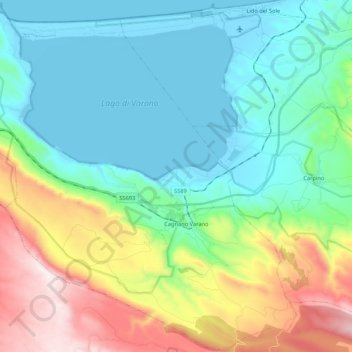
Name: Cagnano Varano topographic map, elevation, terrain.
Location: Cagnano Varano, Foggia, Puglia, 71010, Italia (41.76677 15.63295 41.92303 15.84556)
Average elevation: 820 ft
Minimum elevation: -26 ft
Maximum elevation: 2,986 ft
Make a donation
Gear up for your next adventure:
As an Amazon Associate, this site earns from qualifying purchases at no extra cost to you.
Other topographic maps
Click on a map to view its topography, its elevation and its terrain.
Make a donation
Gear up for your next adventure:
As an Amazon Associate, this site earns from qualifying purchases at no extra cost to you.