
Make a donation
Gear up for your next adventure:
As an Amazon Associate, this site earns from qualifying purchases at no extra cost to you.
Haena topographic map
Click on the map to display elevation.
Make a donation
Gear up for your next adventure:
As an Amazon Associate, this site earns from qualifying purchases at no extra cost to you.
About this map
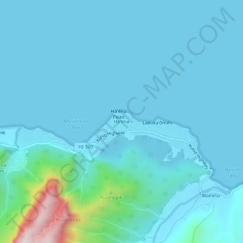
Name: Haena topographic map, elevation, terrain.
Location: Haena, Kauaʻi County, Hawaii, United States (22.20469 -159.57790 22.24469 -159.53790)
Average elevation: 207 ft
Minimum elevation: -3 ft
Maximum elevation: 2,096 ft
Kauaʻi County trails, hiking, mountain biking, running and outdoor activities
Make a donation
Gear up for your next adventure:
As an Amazon Associate, this site earns from qualifying purchases at no extra cost to you.
Other topographic maps
Click on a map to view its topography, its elevation and its terrain.
Niihau
United States > Hawaii > Kauaʻi County > Puuwai
Niʻihau is located about 18 miles (29 km) west of Kauaʻi, and the tiny, uninhabited island of Lehua lies 0.7 miles (0.61 nmi; 1.1 km) north of Niʻihau. Niʻihau's dimensions are 6.2 miles by 18.6 miles (10 km × 30 km). The maximum elevation (Paniau) is 1,280 feet (390 m). The island is about 6 million…
Average elevation: 75 ft
Make a donation
Gear up for your next adventure:
As an Amazon Associate, this site earns from qualifying purchases at no extra cost to you.
Alaka‘i Swamp
United States > Hawaii > Kauaʻi County
The Alakaʻi Wilderness Preserve, popularly known as Alakaʻi Swamp, is a montane wet forest on the Hawaiian island of Kauaʻi. Although the preserve is home to alpine bogs, it is not a true swamp.[1] It is located on a plateau near Mount Waiʻaleʻale, one of the wettest spots on Earth. Due to its unique…
Average elevation: 2,949 ft
Make a donation
Gear up for your next adventure:
As an Amazon Associate, this site earns from qualifying purchases at no extra cost to you.
Make a donation
Gear up for your next adventure:
As an Amazon Associate, this site earns from qualifying purchases at no extra cost to you.
Make a donation
Gear up for your next adventure:
As an Amazon Associate, this site earns from qualifying purchases at no extra cost to you.