
Make a donation
Gear up for your next adventure:
As an Amazon Associate, this site earns from qualifying purchases at no extra cost to you.
Palmas topographic map
Click on the map to display elevation.
Make a donation
Gear up for your next adventure:
As an Amazon Associate, this site earns from qualifying purchases at no extra cost to you.
Palmas
Palmas is a municipality in the south of the Brazilian state of Paraná. Palmas is located in the mountainous area of Paraná and is in the mesoregion of South-Central Paraná. Palmas is the capital of the microregion of the same name. The population is 51,755 (2020 est.) in an area of 1557.90 km2. The elevation is 1,056 m.
Make a donation
Gear up for your next adventure:
As an Amazon Associate, this site earns from qualifying purchases at no extra cost to you.
About this map
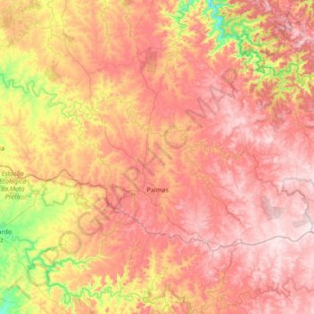
Name: Palmas topographic map, elevation, terrain.
Average elevation: 3,428 ft
Minimum elevation: 2,283 ft
Maximum elevation: 4,331 ft
Make a donation
Gear up for your next adventure:
As an Amazon Associate, this site earns from qualifying purchases at no extra cost to you.