
Make a donation
Gear up for your next adventure:
As an Amazon Associate, this site earns from qualifying purchases at no extra cost to you.
Ciucaș topographic map
Click on the map to display elevation.
Make a donation
Gear up for your next adventure:
As an Amazon Associate, this site earns from qualifying purchases at no extra cost to you.
About this map
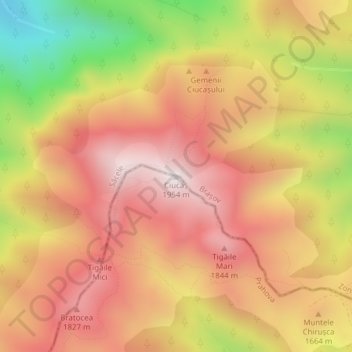
Name: Ciucaș topographic map, elevation, terrain.
Location: Ciucaș, Măneciu, Prahova, Romania (45.52163 25.92643 45.52173 25.92653)
Average elevation: 5,266 ft
Minimum elevation: 3,527 ft
Maximum elevation: 6,388 ft
Make a donation
Gear up for your next adventure:
As an Amazon Associate, this site earns from qualifying purchases at no extra cost to you.
Other topographic maps
Click on a map to view its topography, its elevation and its terrain.
Sinaia
Sinaia is about 65 kilometres (40 miles) northwest of Ploiești and 48 kilometres (30 miles) south of Brașov, in a mountainous area on the Prahova River valley, just east of the Bucegi Mountains. The town's altitude varies between 767 to 860 metres (2,516 to 2,822 feet) above sea level.
Average elevation: 4,098 ft
Comarnic
The town is situated in the southern foothills of the Carpathian Mountains, close to the interface between the Southern Carpathians and the Eastern Carpathians, at an altitude of 555 m (1,821 ft). It lies towards the southern end of the Prahova Valley, along the Prahova River, in the main on the left bank, but…
Average elevation: 2,904 ft
Ploiești
The city lies on the Wallachian Plain, having an average altitude of 150 m (490 ft). The surrounding landscape is influenced by its position around the Prahova River, whose stream bed lies 25 km (16 mi) to the west. The Teleajen River passes through the city while the Dâmbu River passes through the…
Average elevation: 518 ft
Make a donation
Gear up for your next adventure:
As an Amazon Associate, this site earns from qualifying purchases at no extra cost to you.
Make a donation
Gear up for your next adventure:
As an Amazon Associate, this site earns from qualifying purchases at no extra cost to you.
Bușteni
Bușteni (Romanian pronunciation: [buʃˈtenʲ]) is a small mountain town in the north of Prahova County, Muntenia, Romania. It is located in the Prahova Valley, at the bottom of the Bucegi Mountains, that have a maximum altitude of 2,505 m (8,219 ft). Its name literally means tree-logs in Romanian. One…
Average elevation: 4,656 ft
Make a donation
Gear up for your next adventure:
As an Amazon Associate, this site earns from qualifying purchases at no extra cost to you.
Make a donation
Gear up for your next adventure:
As an Amazon Associate, this site earns from qualifying purchases at no extra cost to you.
Make a donation
Gear up for your next adventure:
As an Amazon Associate, this site earns from qualifying purchases at no extra cost to you.
Make a donation
Gear up for your next adventure:
As an Amazon Associate, this site earns from qualifying purchases at no extra cost to you.
Make a donation
Gear up for your next adventure:
As an Amazon Associate, this site earns from qualifying purchases at no extra cost to you.
Make a donation
Gear up for your next adventure:
As an Amazon Associate, this site earns from qualifying purchases at no extra cost to you.
Ploiești
The city lies on the Wallachian Plain, having an average altitude of 150 m (490 ft). The surrounding landscape is influenced by its position around the Prahova River, whose stream bed lies 25 km (16 mi) to the west. The Teleajen River passes through the city while the Dâmbu River passes through the…
Average elevation: 518 ft
Make a donation
Gear up for your next adventure:
As an Amazon Associate, this site earns from qualifying purchases at no extra cost to you.
Make a donation
Gear up for your next adventure:
As an Amazon Associate, this site earns from qualifying purchases at no extra cost to you.
Ploiești
The city lies on the Wallachian Plain, having an average altitude of 150 m (490 ft). The surrounding landscape is influenced by its position around the Prahova River, whose stream bed lies 25 km (16 mi) to the west. The Teleajen River passes through the city while the Dâmbu River passes through the…
Average elevation: 518 ft
Sinaia
Sinaia is about 65 kilometres (40 miles) northwest of Ploiești and 48 kilometres (30 miles) south of Brașov, in a mountainous area on the Prahova River valley, just east of the Bucegi Mountains. The town's altitude varies between 767 to 860 metres (2,516 to 2,822 feet) above sea level.
Average elevation: 4,098 ft
Make a donation
Gear up for your next adventure:
As an Amazon Associate, this site earns from qualifying purchases at no extra cost to you.
Make a donation
Gear up for your next adventure:
As an Amazon Associate, this site earns from qualifying purchases at no extra cost to you.