Geolocate

Crofton topographic map

Click on the map to display elevation.

About this map

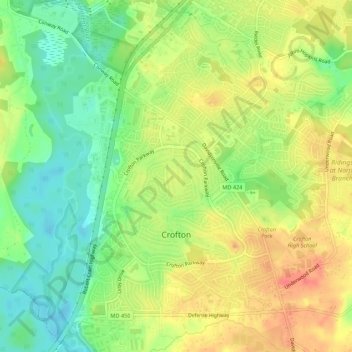
Name: Crofton topographic map, elevation, terrain.

Location: Crofton, Anne Arundel County, Maryland, United States (38.98894 -76.70799 39.04307 -76.65042)

Average elevation: 115 ft

Minimum elevation: 20 ft

Maximum elevation: 203 ft

Gear up for your next adventure:

GPS Sports Watch - GPS watch for running, hiking and training
🚁Photography Drones - Capture stunning aerial views of landforms and topography
🎒Waterproof Dry Bags - Keep your electronics and maps dry inside your pack
📚USA Hiking Guide Books - Top trail guides and map books
🛡️Bear Spray Outdoor - Protection in bear country hikes

As an Amazon Associate, this site earns from qualifying purchases at no extra cost to you.