
Make a donation
Gear up for your next adventure:
As an Amazon Associate, this site earns from qualifying purchases at no extra cost to you.
Lake Yamanaka topographic map
Click on the map to display elevation.
Make a donation
Gear up for your next adventure:
As an Amazon Associate, this site earns from qualifying purchases at no extra cost to you.
Lake Yamanaka
Lake Yamanaka is the largest of the Fuji Five Lakes in surface area and the highest in elevation. It is the third highest lake in Japan, with a mean surface altitude of 980.5 metres (3,217 ft). It is also the shallowest of the Fuji Five Lakes, with a maximum water depth of 13.5 metres (44 ft). It was formed by lava flows from an ancient eruption of Mount Fuji. It is drained by the Sagami River and is the only one of the Fuji Five Lakes to have a natural outflow.
Make a donation
Gear up for your next adventure:
As an Amazon Associate, this site earns from qualifying purchases at no extra cost to you.
About this map
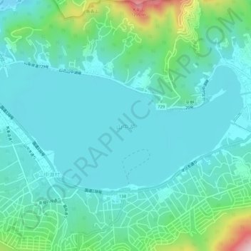
Name: Lake Yamanaka topographic map, elevation, terrain.
Average elevation: 3,379 ft
Minimum elevation: 3,163 ft
Maximum elevation: 4,311 ft
Make a donation
Gear up for your next adventure:
As an Amazon Associate, this site earns from qualifying purchases at no extra cost to you.