
Make a donation
Gear up for your next adventure:
As an Amazon Associate, this site earns from qualifying purchases at no extra cost to you.
Phokeng topographic map
Click on the map to display elevation.
Make a donation
Gear up for your next adventure:
As an Amazon Associate, this site earns from qualifying purchases at no extra cost to you.
About this map
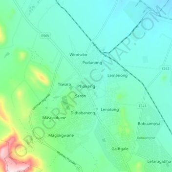
Name: Phokeng topographic map, elevation, terrain.
Average elevation: 3,944 ft
Minimum elevation: 3,635 ft
Maximum elevation: 5,167 ft
Make a donation
Gear up for your next adventure:
As an Amazon Associate, this site earns from qualifying purchases at no extra cost to you.
Other topographic maps
Click on a map to view its topography, its elevation and its terrain.
Vaalkop Dam
South Africa > North West > Bojanala Platinum District Municipality > Rustenburg Local Municipality
Average elevation: 3,238 ft
Kgaswane Mountain Nature Reserve
South Africa > North West > Bojanala Platinum District Municipality > Rustenburg Local Municipality
Average elevation: 4,288 ft