Geolocate

Conley topographic map

Click on the map to display elevation.

About this map

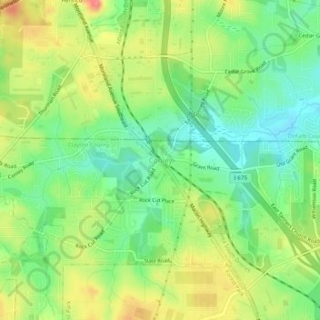
Name: Conley topographic map, elevation, terrain.

Location: Conley, Clayton County, Georgia, 30288, United States (33.62483 -84.34576 33.66483 -84.30576)

Average elevation: 886 ft

Minimum elevation: 781 ft

Maximum elevation: 1,024 ft

Clayton County trails, hiking, mountain biking, running and outdoor activities

Other topographic maps

Click on a map to view its topography, its elevation and its terrain.

Morrow

United States > Georgia > Clayton County

Average elevation: 906 ft

Riverdale

United States > Georgia > Clayton County

Average elevation: 892 ft

Jonesboro

United States > Georgia > Clayton County

Average elevation: 883 ft

Lovejoy

United States > Georgia > Clayton County

Average elevation: 902 ft

Gear up for your next adventure:

📶Satellite Messenger - Communication device off‑grid
🩹Survival Bandages - High‑quality bandages for emergencies
🪶Camp Gear Gift Set - Perfect gift bundle for outdoor fans
🔥Fast-Boil Camping Stoves - Efficient cooking systems for quick trail meals
📦Dry Bags Set - Waterproof storage for electronics and clothes

As an Amazon Associate, this site earns from qualifying purchases at no extra cost to you.