
Stoke topographic map
Click on the map to display elevation.
About this map
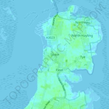
Name: Stoke topographic map, elevation, terrain.
Location: Stoke, Havant, Hampshire, England, PO11 0LE, United Kingdom (50.79673 -0.99913 50.83673 -0.95913)
Average elevation: 3 ft
Minimum elevation: -10 ft
Maximum elevation: 33 ft
Other topographic maps
Click on a map to view its topography, its elevation and its terrain.
Hayling Island
United Kingdom > England > Hampshire > Havant > North Hayling
An Iron Age shrine in the north of Hayling Island was later developed into a Roman temple in the 1st century BC and was first recorded in Richard Scott's Topographical and Historical Account of Hayling Island (1826). The site was dug between 1897 and 1907 and again from 1976 to 1978. The remains are now buried…
Average elevation: 3 ft
Hayling Island
United Kingdom > England > Hampshire > Havant > Fleet
An Iron Age shrine in the north of Hayling Island was later developed into a Roman temple in the 1st century BC and was first recorded in Richard Scott's Topographical and Historical Account of Hayling Island (1826). The site was dug between 1897 and 1907 and again from 1976 to 1978. The remains are now buried…
Average elevation: 3 ft