
Make a donation
Gear up for your next adventure:
As an Amazon Associate, this site earns from qualifying purchases at no extra cost to you.
Horn topographic map
Click on the map to display elevation.
Make a donation
Gear up for your next adventure:
As an Amazon Associate, this site earns from qualifying purchases at no extra cost to you.
Horn
Der Kern der Siedlung Horn befand sich auf einem höhergelegenen Landstück, das zwischen Kleiner Wümme und Vahrster Fleet (Gete) spitz zulief. Die Kleine Wümme durchzog die Siedlung von der Achterstraße über die Riensberger Straße und Berckstraße bis zur Straße Schorf. Ein großer Teil des Flusslaufs im Zentrum Horns ist zugeschüttet worden. Heute ist die kleine Wümme nur noch bis zur Riensberger Straße vorhanden.
Make a donation
Gear up for your next adventure:
As an Amazon Associate, this site earns from qualifying purchases at no extra cost to you.
About this map
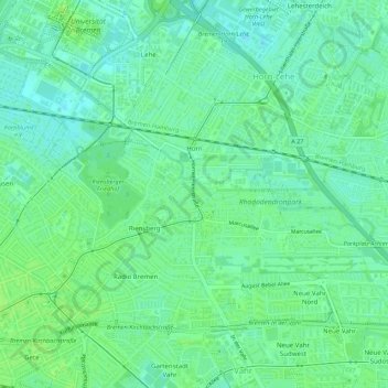
Name: Horn topographic map, elevation, terrain.
Location: Horn, Horn-Lehe, Bremen-Ost, Bremen, Deutschland (53.08689 8.85014 53.10035 8.90491)
Average elevation: 20 ft
Minimum elevation: 0 ft
Maximum elevation: 33 ft
Make a donation
Gear up for your next adventure:
As an Amazon Associate, this site earns from qualifying purchases at no extra cost to you.
Other topographic maps
Click on a map to view its topography, its elevation and its terrain.
Make a donation
Gear up for your next adventure:
As an Amazon Associate, this site earns from qualifying purchases at no extra cost to you.