
Make a donation
Gear up for your next adventure:
As an Amazon Associate, this site earns from qualifying purchases at no extra cost to you.
Monte Luco topographic map
Click on the map to display elevation.
Make a donation
Gear up for your next adventure:
As an Amazon Associate, this site earns from qualifying purchases at no extra cost to you.
Monte Luco
Il Monte Luco (anche Monteluco o Colle di Roio) è un rilievo dell'Appennino abruzzese, posto nella conca aquilana, interamente nel comune dell'Aquila, in Abruzzo, raggiungendo un'altitudine di 987 m s.l.m. e dominando da sud l'intera città con 360 m di prominenza sulla sottostante valle dell'Aterno.
Make a donation
Gear up for your next adventure:
As an Amazon Associate, this site earns from qualifying purchases at no extra cost to you.
About this map
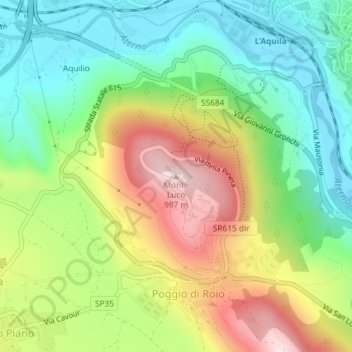
Name: Monte Luco topographic map, elevation, terrain.
Location: Monte Luco, L'Aquila, Abruzzo, Italia (42.33983 13.37504 42.33993 13.37514)
Average elevation: 2,497 ft
Minimum elevation: 2,005 ft
Maximum elevation: 3,241 ft
Make a donation
Gear up for your next adventure:
As an Amazon Associate, this site earns from qualifying purchases at no extra cost to you.
Other topographic maps
Click on a map to view its topography, its elevation and its terrain.