
Thank you for supporting this site ❤️
Make a donation
Make a donation
Gear up for your next adventure:
As an Amazon Associate, this site earns from qualifying purchases at no extra cost to you.
Queenstown topographic map
Click on the map to display elevation.
Thank you for supporting this site ❤️
Make a donation
Make a donation
Gear up for your next adventure:
As an Amazon Associate, this site earns from qualifying purchases at no extra cost to you.
About this map
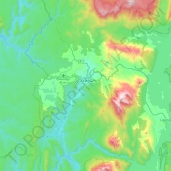
Name: Queenstown topographic map, elevation, terrain.
Location: Queenstown, West Coast, Tasmania, 7467, Australia (-42.17022 145.47523 -42.00032 145.60579)
Average elevation: 1,083 ft
Minimum elevation: 151 ft
Maximum elevation: 3,717 ft
Thank you for supporting this site ❤️
Make a donation
Make a donation
Gear up for your next adventure:
As an Amazon Associate, this site earns from qualifying purchases at no extra cost to you.