Geolocate

Luck topographic map

Click on the map to display elevation.

About this map

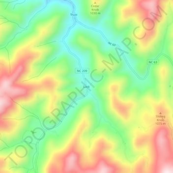
Name: Luck topographic map, elevation, terrain.

Location: Luck, Madison County, North Carolina, United States (35.71594 -82.88625 35.75594 -82.84625)

Average elevation: 3,100 ft

Minimum elevation: 2,382 ft

Maximum elevation: 3,980 ft

Madison County trails, hiking, mountain biking, running and outdoor activities

Gear up for your next adventure:

❄️Traction Cleats - Prevent slips on icy trails during winter hikes
🛠️Outdoor Gear Repair Kit - Essential tools to fix gear on the trail
🚗GPS Dash Cams - Record your scenic drives through mountain passes and canyons
📷Action Camera - Capture your outdoor adventures in HD
🎁Geography Themed Gifts - Unique gift ideas for map lovers and geography enthusiasts

As an Amazon Associate, this site earns from qualifying purchases at no extra cost to you.