
Thank you for supporting this site ❤️
Make a donation
Make a donation
Gear up for your next adventure:
As an Amazon Associate, this site earns from qualifying purchases at no extra cost to you.
Butiama topographic map
Click on the map to display elevation.
Thank you for supporting this site ❤️
Make a donation
Make a donation
Gear up for your next adventure:
As an Amazon Associate, this site earns from qualifying purchases at no extra cost to you.
About this map
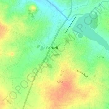
Name: Butiama topographic map, elevation, terrain.
Location: Butiama, Bariadi Town, Simiyu, Lake Zone, Tanzania (-2.82605 33.96789 -2.78605 34.00789)
Average elevation: 4,229 ft
Minimum elevation: 4,157 ft
Maximum elevation: 4,308 ft
Thank you for supporting this site ❤️
Make a donation
Make a donation
Gear up for your next adventure:
As an Amazon Associate, this site earns from qualifying purchases at no extra cost to you.