
Lenin Peak topographic map
Interactive map
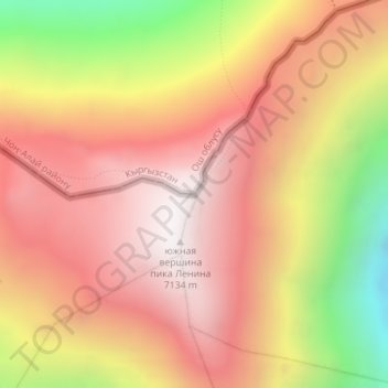
Click on the map to display elevation.
About this map
Name: Lenin Peak topographic map, elevation, terrain.
Average elevation: 21,535 ft
Minimum elevation: 18,556 ft
Maximum elevation: 23,366 ft
Local Kyrgyz names include Jel-Aidar ("Wind's God") and Achyk-Tash ("Open Rock"). Achik-Tash, is also the name of a plateau and a base camp at an elevation of 3,600 m on a popular northern climbing route to Lenin Peak, which starts in the southern Kyrgyz city of Osh, a day's drive north of the border. Another suggested local name, Pik Kaman ("wild pig", "boar") probably belongs to an officially unnamed peak west of Lenin Peak.
Other topographic maps
Click on a map to view its topography, its elevation and its terrain.
Россия
Tajikistan > Gorno-Badakhshan Autonomous Region > Murghob District
Россия, Murghob District, Gorno-Badakhshan Autonomous Region, Tajikistan
Average elevation: 20,013 ft
Pamir Mountains
Tajikistan > Gorno-Badakhshan Autonomous Region > Murghob District
Pamir Mountains, Murghob District, Gorno-Badakhshan Autonomous Region, Tajikistan
Average elevation: 20,850 ft