
Make a donation
Gear up for your next adventure:
As an Amazon Associate, this site earns from qualifying purchases at no extra cost to you.
Bracht-Siedlung topographic map
Click on the map to display elevation.
Make a donation
Gear up for your next adventure:
As an Amazon Associate, this site earns from qualifying purchases at no extra cost to you.
About this map
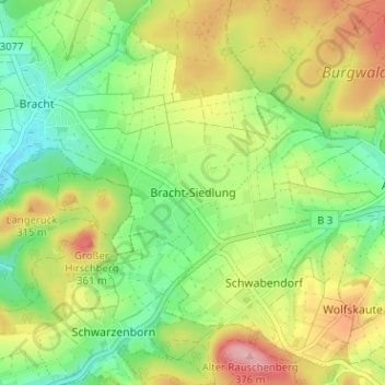
Name: Bracht-Siedlung topographic map, elevation, terrain.
Average elevation: 951 ft
Minimum elevation: 751 ft
Maximum elevation: 1,227 ft
Make a donation
Gear up for your next adventure:
As an Amazon Associate, this site earns from qualifying purchases at no extra cost to you.
Other topographic maps
Click on a map to view its topography, its elevation and its terrain.
Schwabendorf
Deutschland > Hessen > Landkreis Marburg-Biedenkopf > Rauschenberg
Seit Ende November 2011 läuft auf dem Gelände des Schwabendorfer Ortslandwirtes eine Biogasanlage, die dieser mit zwei weiteren Bauern aus der Region betreibt. Ebenfalls im November wurde im Ort eine Genossenschaft gegründet, die ein Nahwärmenetz aufbaut und die Abwärme der Biogasanlage abnimmt. Die…
Average elevation: 955 ft
Josbach
Deutschland > Hessen > Landkreis Marburg-Biedenkopf > Rauschenberg
Average elevation: 1,004 ft
Albshausen
Deutschland > Hessen > Landkreis Marburg-Biedenkopf > Rauschenberg
Average elevation: 942 ft