
Sebago topographic map
Click on the map to display elevation.
Sebago
According to the United States Census Bureau, the town has a total area of 48.93 square miles (126.73 km2), of which 32.76 square miles (84.85 km2) is land and 16.17 square miles (41.88 km2) is water. Situated beside Sebago Lake, Sebago is drained by the Northwest River and Mill Brook. Douglas Mountain has an elevation of 1,416 feet (432 m) above sea level, the highest point in both the town and southwestern Maine.
About this map
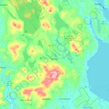
Name: Sebago topographic map, elevation, terrain.
Location: Sebago, Cumberland County, Maine, 04029, United States (43.83376 -70.75793 43.96182 -70.53564)
Average elevation: 525 ft
Minimum elevation: 246 ft
Maximum elevation: 1,375 ft
Cumberland County trails, hiking, mountain biking, running and outdoor activities
Other topographic maps
Click on a map to view its topography, its elevation and its terrain.
Littlejohn Island
United States > Maine > Cumberland County > Yarmouth > Cousins Island
Average elevation: 16 ft