Geolocate

Helena topographic map

Click on the map to display elevation.

About this map

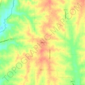
Name: Helena topographic map, elevation, terrain.

Location: Helena, Andrew County, Missouri, 64459, United States (39.89277 -94.66941 39.93277 -94.62941)

Average elevation: 1,014 ft

Minimum elevation: 906 ft

Maximum elevation: 1,083 ft

Andrew County trails, hiking, mountain biking, running and outdoor activities

Other topographic maps

Click on a map to view its topography, its elevation and its terrain.

Savannah

United States > Missouri > Andrew County

Average elevation: 1,079 ft

Cosby

United States > Missouri > Andrew County

Average elevation: 932 ft

Gear up for your next adventure:

🎒Hydration Pack - Hands‑free water reservoir for long hikes
🧯Emergency Survival Kit - All‑in‑one survival essentials for the backcountry
🥇GPS Hiking Watch - Multi‑sport GPS watch with navigation and trail tracking
🔥Plasma Lighters - Windproof lighters that work in any weather condition
🛌Ultralight Sleeping Bags - Compact down bags for cold nights in the wilderness

As an Amazon Associate, this site earns from qualifying purchases at no extra cost to you.