
Make a donation
Gear up for your next adventure:
As an Amazon Associate, this site earns from qualifying purchases at no extra cost to you.
Eikeloh topographic map
Click on the map to display elevation.
Make a donation
Gear up for your next adventure:
As an Amazon Associate, this site earns from qualifying purchases at no extra cost to you.
Eikeloh
Das Dorf Eikeloh, mit zurzeit 504 Einwohnern, liegt etwa drei Kilometer östlich von Erwitte am nördlichen Fuß des Haarstranges. Der niedrigste Punkt von Eikeloh (97,5 m ü. NN) liegt an der Grenze zu Bökenförde, zum Süden hin steigt der Ort bis auf 167,5 m ü. NN an. Die Kirche liegt auf einer Höhe von 110 m ü. NN. Eikeloh liegt wie Erwitte am ehemaligen Hellweg, der heutigen Bundesstraße 1.
Make a donation
Gear up for your next adventure:
As an Amazon Associate, this site earns from qualifying purchases at no extra cost to you.
About this map
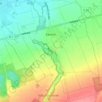
Name: Eikeloh topographic map, elevation, terrain.
Location: Eikeloh, Erwitte, Kreis Soest, Nordrhein-Westfalen, Deutschland (51.59414 8.38871 51.63286 8.43138)
Average elevation: 400 ft
Minimum elevation: 292 ft
Maximum elevation: 564 ft
Make a donation
Gear up for your next adventure:
As an Amazon Associate, this site earns from qualifying purchases at no extra cost to you.
Other topographic maps
Click on a map to view its topography, its elevation and its terrain.
Bad Westernkotten
Deutschland > Nordrhein-Westfalen > Kreis Soest > Erwitte
Wirtschaftlich spielte im 19. Jahrhundert die Salzindustrie weiterhin die wichtigste Rolle und erreichte mit einer jährlichen Produktion von etwa 35.000 Zentnern um 1850 ihren Höhepunkt.
Average elevation: 308 ft