Morgan Mill topographic map
Interactive map
Click on the map to display elevation.
About this map
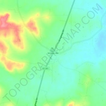
Name: Morgan Mill topographic map, elevation, terrain.
Location: Morgan Mill, Erath County, Texas, 76465, United States (32.36819 -98.18726 32.40819 -98.14726)
Average elevation: 1,083 ft
Minimum elevation: 988 ft
Maximum elevation: 1,283 ft
Other topographic maps
Click on a map to view its topography, its elevation and its terrain.
Lingleville
United States > Texas > Erath County
Lingleville, Erath County, Texas, 76461, United States
Average elevation: 1,503 ft
Dublin
United States > Texas > Erath County
Dublin, Erath County, Texas, 76446, United States
Average elevation: 1,480 ft
Stephenville
United States > Texas > Erath County
Stephenville, Erath County, Texas, United States
Average elevation: 1,319 ft
Thurber
United States > Texas > Erath County
Thurber, Erath County, Texas, 76463, United States
Average elevation: 1,066 ft
Bluff Dale
United States > Texas > Erath County
Bluff Dale, Erath County, Texas, 76433, United States
Average elevation: 948 ft