Troy topographic map
Click on the map to display elevation.
Troy
The western edge of the city is flat along the river, and then steeply slopes to higher terrain to the east. The average elevation is 50 feet, with the highest elevation being 500 feet in the eastern part of the city. The city is longer than it is wide, with the southern part wider than the northern section of the city (the formerly separate city of Lansingburgh). Several kills (Dutch for creek) pass through Troy and empty into the Hudson. The Poesten Kill and Wynants Kill are the two largest, and both have several small lakes and waterfalls along their routes in the city. Several lakes and reservoirs are within the city, including Ida Lake, Burden Pond, Lansingburgh Reservoir, Bradley Lake, Smarts Pond, and Wright Lake.
About this map
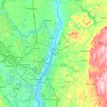
Name: Troy topographic map, elevation, terrain.
Location: Troy, Rensselaer County, New York, 12181, United States (42.56841 -73.85179 42.88841 -73.53179)
Average elevation: 449 ft
Minimum elevation: -7 ft
Maximum elevation: 1,667 ft
Rensselaer County trails, hiking, mountain biking, running and outdoor activities
Other topographic maps
Click on a map to view its topography, its elevation and its terrain.
East Greenbush CDP
United States > New York > Rensselaer County > Town of East Greenbush
The western section of the town along the Hudson River is marked by bluffs that rise to an elevation of between 100 and 300 feet. The little flat land that exists along the river is on the Papscanee Island. Papscanee Island is actually a peninsula, separated from the rest of the town by the Papscanee Creek.…
Average elevation: 315 ft
Town of East Greenbush
United States > New York > Rensselaer County
The western section of the town, along the Hudson River is marked by bluffs that rise to an elevation of between 100 and 300 feet. The little flat land that exists along the river is on the Papscanee Island. Papscanee Island is actually a peninsula, separated from the rest of the town by the Papscanee Creek.…
Average elevation: 292 ft
Walloomsac Dam
United States > New York > Rensselaer County > Town of Hoosick > Walloomsac
Average elevation: 627 ft