
Guangzhou topographic map
Click on the map to display elevation.
Guangzhou
The elevation of the prefecture generally increases from southwest to northeast, with mountains forming the backbone of the city and the ocean comprising the front. Tiantang Peak (天堂顶, "Heavenly Peak") is the highest point of elevation at 1,210 metres (3,970 ft) above sea level.
About this map
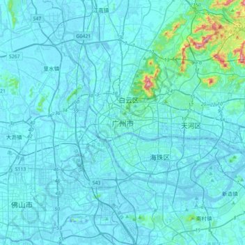
Name: Guangzhou topographic map, elevation, terrain.
Location: Guangzhou, Guangzhou City, Guangdong Province, 510030, China (22.97020 113.09929 23.29020 113.41929)
Average elevation: 69 ft
Minimum elevation: -49 ft
Maximum elevation: 1,194 ft